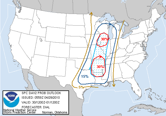
Indication map is for tomorrow's probabilities for Severe Weather...
This is from the Jackson, MS HWO.
Quote:
DAYS TWO THROUGH SEVEN...THURSDAY NIGHT THROUGH TUESDAY MULTIPLE ROUNDS OF SEVERE THUNDERSTORMS AND POSSIBLE FLASH FLOODING ARE EXPECTED FRIDAY...FRIDAY NIGHT AND SATURDAY. SEVERE THUNDERSTORMS WILL BE CAPABLE OF PRODUCING LARGE HAIL...DAMAGING WINDS AND TORNADOES. ALL AREAS OF THE FORECAST AREA WILL SEE THE POTENTIAL FOR SEVERE WEATHER. THE BEST CHANCES FOR SEVERE THUNDERSTORMS WILL OCCUR WEST AND NORTH OF A LINE FROM BROOKHAVEN TO MERIDIAN WITH THE GREATEST POTENTIAL EXPECTED OVER THE DELTA REGION FROM NATCHEZ TO GRENADA..
SPOTTER CALL TO ACTION STATEMENT...THE ACTIVATION OF STORM SPOTTERS...HAM RADIO OPERATORS...AND EMERGENCY MANAGEMENT PERSONNEL IN SUPPORT OF SEVERE WEATHER OPERATIONS MAY BE NEEDED FRIDAY THROUGH SUNDAY.
With my parents starting a road trip to Peoria, Illinois tomorrow, I will be monitoring this situation carefully.
The Weather Channel's severe weather expert Dr. Greg Forbes says the next several days could be stormy.
UPDATED at 4:07PM: Dr. Forbes' updated areas of risk for tomorrow are not as advanced to the East as before, probably due to the large high pressure system in the Northeast pushing it back.
Here is their map for today's risk areas.

Stay tuned.
xoxosgs
1 comment:
Are they Marching To Peoria?
Post a Comment